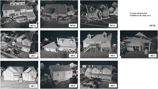
2022 APR 27 (NewsRx) -- By a News Reporter-Staff News Editor at Information Technology Daily -- Investigators publish new report on Information Technology - Cloud Computing. According to news reporting originating from Piscataway, New Jersey, by NewsRx correspondents, research stated, “Factors that often make coastal areas prone to high-cost flood damage include its low-lying topography, tropical and subtropical climates, miles of coastline exposed to hurricane and storm surge hazards, and older housing stock. In this study, we sought to develop a platform that can be used by various stakeholders to re-evaluate and reframe community risk through the use of mobile LiDAR technology to create a current 3D digital elevation model of all homes, businesses, and infrastructure in shoreline communities within the current 100-year floodplain in one county in New Jersey.”
Financial support for this research came from U.S. Federal Emergency Management Agency (FEMA).
Our news editors obtained a quote from the research from the Rutgers University - The State University of New Jersey, “An innovative strategy for extracting property elevation information from mobile LiDAR and mobile imagery was developed utilizing a web-based approach. Unlike traditional elevation extraction approaches that require field surveys, the proposed method does not require an onsite inspection from certified surveyors, which is often computationally expensive but the key method to current elevation certificate generation. Thus, the proposed approach makes it possible to obtain accurate structure elevation and realize the elevation extraction for large-scale community areas. Results indicate that overall, 96.5% of building diagrams identified with our method have the same value as the original elevation certificate documents. For the estimation of elevation certificate C2a elevation, the estimated error is between 0.082 ft (0.025 m) and 0.104 ft (0.032 m) at the 95% confidence level.”

According to the news editors, the research concluded: “Similarly, the C2b elevation had an estimated error be-tween 0.133 ft (0.040 m) and 0.136 ft (0.041 m) at the 95% confidence level.”
This research has been peer-reviewed.
For more information on this research see: Large-scale Cloud-based Building Elevation Data Extraction and Flood Insurance Estimation To Support Floodplain Management. International Journal of Disaster Risk Reduction, 2022;69. International Journal of Disaster Risk Reduction can be contacted at: Elsevier, Radarweg 29, 1043 Nx Amsterdam, Netherlands. (Elsevier - www.elsevier.com; International Journal of Disaster Risk Reduction - http://www.journals.elsevier.com/international-journal-of-disaster-risk-reduction/)
The news editors report that additional information may be obtained by contacting Jie Gong, Rutgers University - The State University of New Jersey, Dept. of Civil and Environmental Engineering, Piscataway, NJ 08854, United States. Additional authors for this research include Mengyang Guo and Jennifer L. Whytlaw.
The direct object identifier (DOI) for that additional information is: https://doi.org/10.1016/j.ijdrr.2021.102741. This DOI is a link to an online electronic document that is either free or for purchase, and can be your direct source for a journal article and its citation.
(Our reports deliver fact-based news of research and discoveries from around the world.)


